
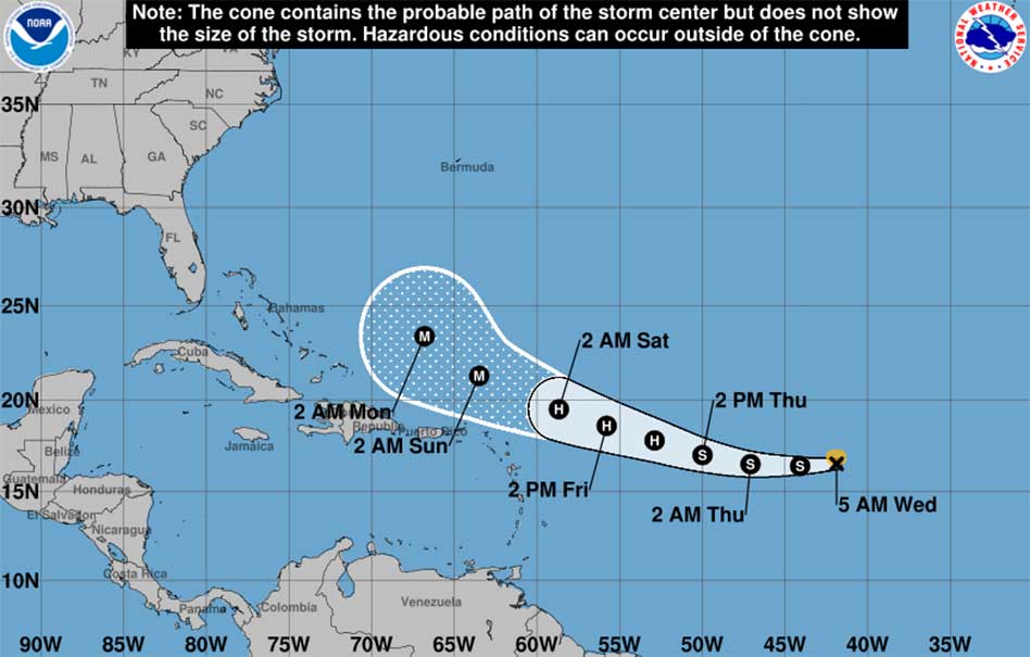
As of 5 a.m. AST, Tropical Storm Erin remains a 40 mph storm located near 16.5°N, 41.9°W, moving west at 17 mph. The storm’s structure is still somewhat disorganized due to easterly wind shear and dry air, but gradual strengthening is expected over the next two days as it moves into warmer waters and a more favorable environment.
Intensity Forecast:
-
Erin is expected to strengthen into the first hurricane of the 2025 Atlantic season by Thursday.
-
Further intensification is possible, and Erin could reach Category 3 (major hurricane) status by Sunday.
Track Forecast:
-
A strong ridge to the north will keep Erin moving generally westward before a gradual turn to the west-northwest later this week.
-
The current forecast keeps Erin north of the Caribbean, including Puerto Rico, over the weekend.
-
Early next week, the storm is expected to begin turning north. It’s too soon to determine whether Erin will pass near Bermuda or track closer to the U.S. East Coast.
Potential Impacts:
-
Northern Leeward Islands, U.S. and British Virgin Islands, and Puerto Rico could see some impacts this weekend, but the extent remains uncertain.
-
Greater Antilles, the Bahamas, Bermuda, and parts of the U.S. East Coast should monitor updates closely in the coming days.
Preparedness Reminder:
With the peak of hurricane season approaching, now is the time to review and update hurricane plans, even if you are not currently in the forecast path. A comprehensive Hurricane Preparedness Guide, available in both English and Spanish, is provided by Kissimmee Utility Authority at KUA.com to help residents prepare before a storm threatens.


