

NOAA National Weather Service forecasters at the Climate Prediction Center predict above-normal hurricane activity in the Atlantic basin this year. NOAA’s outlook for the 2024 Atlantic hurricane season, which spans from June 1 to November 30, predicts an 85% chance of an above-normal season, a 10% chance of a near-normal season, and a 5% chance of a below-normal season.
NOAA forecasts 17 to 25 named storms (winds of 39 mph or higher), 8 to 13 of which could become hurricanes (winds of 74 mph or higher), including 4 to 7 major hurricanes (category 3, 4, or 5; with winds of 111 mph or higher). Forecasters have a 70% confidence in these ranges.
The upcoming Atlantic hurricane season is expected to have above-normal activity due to a confluence of factors, including near-record warm ocean temperatures in the Atlantic Ocean, development of La Nina conditions in the Pacific, reduced Atlantic trade winds, and less wind shear, all of which favor tropical storm formation.
“With another active hurricane season approaching, NOAA’s commitment to keeping every American informed with life-saving information is unwavering,” said NOAA Administrator Rick Spinrad, Ph.D. Enhanced communications and new tools for hurricane analysis and forecasting are part of NOAA’s efforts to improve preparedness and response.
FEMA Deputy Administrator Erik A. Hooks emphasizes the importance of preparation: “Severe weather and emergencies can happen at any moment, which is why individuals and communities need to be prepared today.”
As one of the strongest El Ninos ever observed nears its end, NOAA scientists predict a quick transition to La Nina conditions, which are conducive to Atlantic hurricane activity. Abundant oceanic heat content in the tropical Atlantic Ocean and Caribbean Sea creates more energy to fuel storm development.
Human-caused climate change is warming our ocean globally and in the Atlantic basin, leading to sea level rise, which increases the risk of storm surge. Enhanced communications in store for 2024 season include expanded Spanish language text products and an experimental version of the forecast cone graphic that includes inland tropical storm and hurricane watches and warnings.
NOAA will implement improvements to its forecast communications, decision support, and storm recovery efforts this season. Two new forecast models developed by NOAA researchers will go into operation: the Modular Ocean Model (MOM6) and SDCON, predicting tropical cyclone rapid intensification. NOAA’s new generation of Flood Inundation Mapping will also provide valuable information to emergency and water managers.
System upgrades include coastal weather buoy enhancements, additional observations using Directional Wave Spectra Drifters, deployment of Saildrones, observational underwater gliders, and a new lightweight dropsonde called Streamsonde for real-time wind data collection.
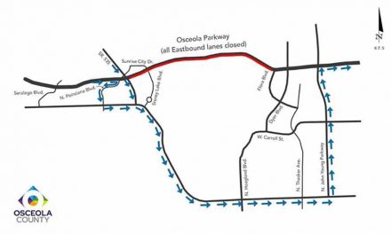
Prepare for the upcoming hurricane season by utilizing Kissimmee Utility Authority’s Hurricane Preparedness Guide, available at their Carroll Street office or downloadable at KUA.com/storm. Both the print and digital versions are bilingual.
SOURCE: NOAA


