
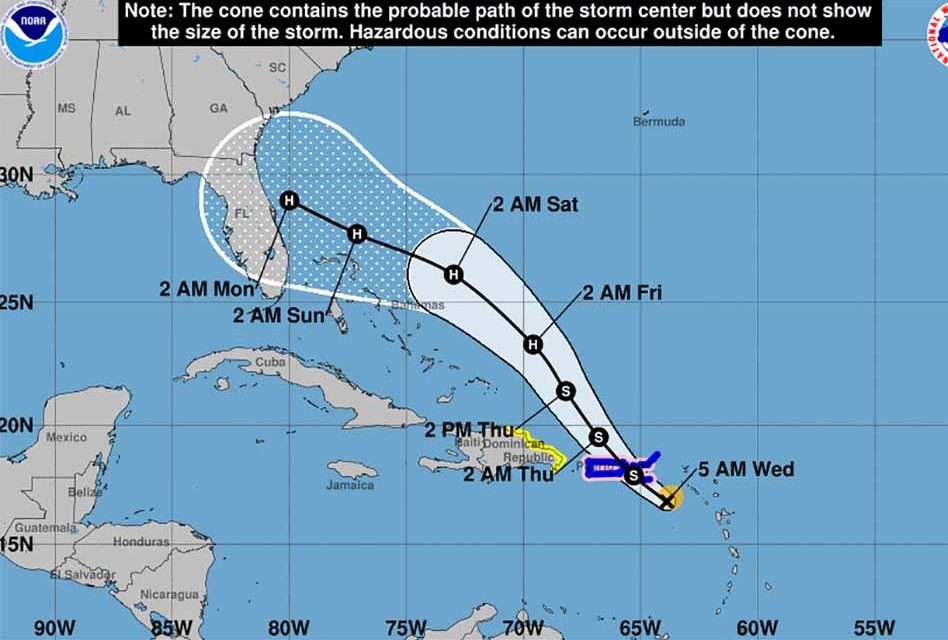
Tropical Storm Dorian continues to move through the warm water of the Caribbean on a projected path towards Central Florida.
The 11 p.m. track for Dorian shows a projected landfall forecast near Volusia County by Sunday at 8 p.m., slightly north of an earlier projection of a Melbourne landfall. At this time it appears that Dorian may arrive as a Category 1 Hurricane.
It’s too soon to tell the exactly how Dorian might arrive in Florida, but here’s what we know about the storm.
As of 5am, the center of Tropical Storm Dorian was located near latitude 16.8 North, longitude 63.9 West. Dorian is moving toward the northwest near 13 mph (20 km/h), and this general
motion is expected to continue during the next few days. On the forecast track, the center of Dorian will pass over or near the U.S. and British Virgin Islands and Puerto Rico later today.
Dorian is then forecast to move to the east of the Turks and Caicos and the southeastern Bahamas on Thursday, and near or to the east of the central and northwestern Bahamas on Friday and Saturday.
Maximum sustained winds are near 60 mph (95 km/h) with higher gusts.
Some strengthening is expected today, and Dorian is forecast to be near hurricane strength when it approaches the Virgin Islands and Puerto Rico. Although weakening is possible after Dorian moves across Puerto Rico and the Virgin Islands, the storm is forecast to strengthen late this week and this weekend while passing near or to the east of the Turks and Caicos and the Bahamas.
Tropical-storm-force winds extend outward up to 60 miles (95 km)from the center.
If the storm does arrive in Florida, it may bring 4 to 8 inches of rain, isolated areas may receive up to 10 inches.


