
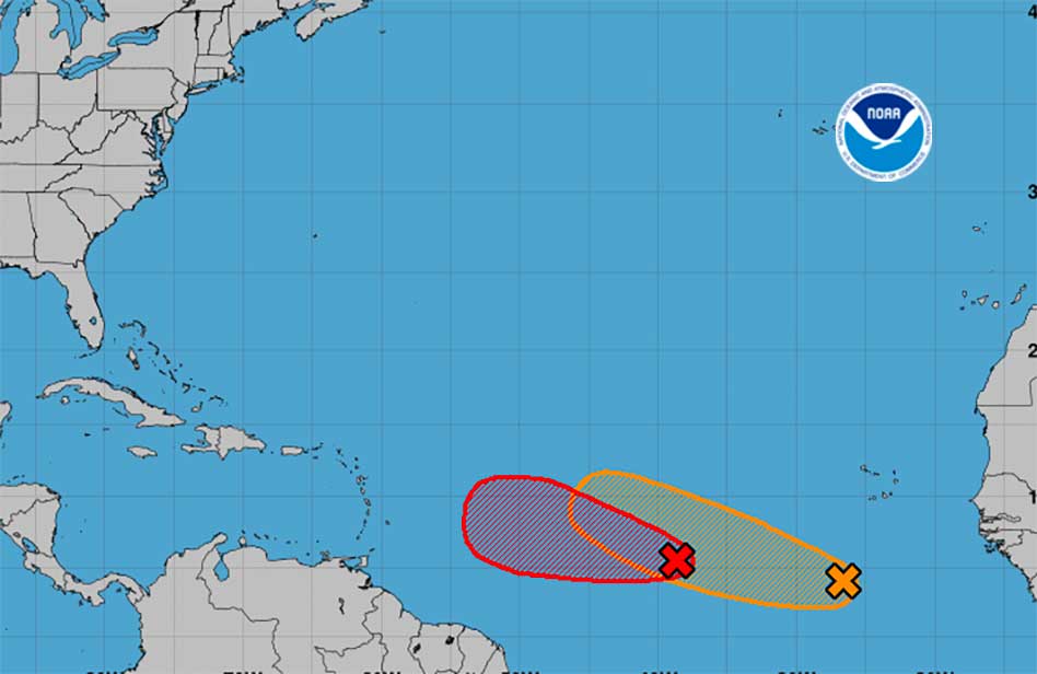
Florida has its eyes turned eastward as the National Hurricane Center is tracking two disturbances brewing in the Atlantic Ocean, with one looking like it will become Tropical Depression Three. If its sustained winds reach 39 mph, it would become Tropical Storm Bret.
The first system is located roughly midway between Africa and the Lesser Antilles and has become better organized overnight. The system’s showers and thunderstorms have continued to become better organized and environmental conditions are 100% conducive for more development. If current trends continue, advisories could be initiated on a tropical depression later today. The system is forecast to move generally westward at 15 to 20 mph with further development across the central tropical Atlantic through the middle part of this week.
The second disturbance is several hundred miles south-southwest of the Cabo Verde Islands. The National Hurricane Center said there could be some gradual development through the middle and end of the week as it moves west at 10 to 15 mph across the eastern and central tropical Atlantic.
The NHC says there is a 30% chance of development through the next 48 hours and 40% chance of development in the next seven days.
The next named storm will be Bret. So far, June is showing signs that the Hurricane Season may be an active one. Hurricane season runs through Nov. 30.
Being prepared is the wisest move we can all make at this point in the Atlantic Hurricane season. For more information, look to Kissimmee Utility Authority’s Hurricane Handbook. It is a free Hurricane preparedness guide that is rich with preparedness tips and informational contact numbers that will help keep you and your family during hurricane season. Go to KUA.com/Storm for more information, or to download the free handbook.


