
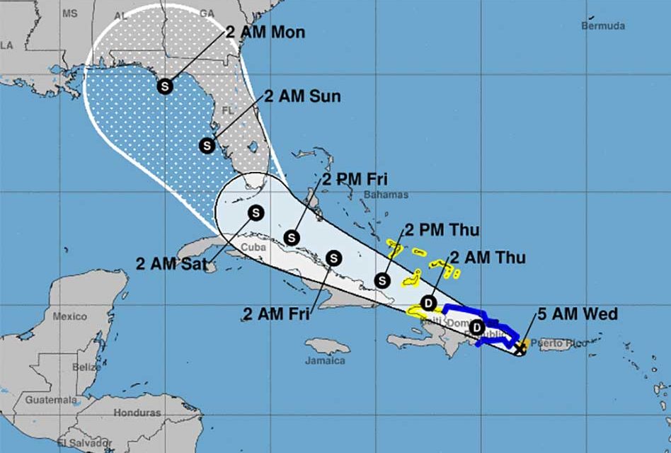
Tropical Storm Fred formed Tuesday night Florida is still in the cone of uncertainty, forecasters with the National Hurricane Center said.
The storm is expected to bring heavy rains and winds across Puerto Rico and over Hispaniola on Wednesday.
According to the 5 am update the system was 115 miles east-southeast of Santo Domingo, Dominican Republic.
The system was moving west-northwest near 16 mph and this is expected to continue during the next few days.
On the forecast track, the disturbance is expected to pass near the southern coast of Puerto Rico, and on Wednesday, it should be near or over Hispaniola. Forecasters say it will also be near the southeastern Bahamas and the Turks and Caicos Islands on Thursday.
Maximum sustained winds are at around 40 mph with higher gusts with these current Tropical Storm Warnings:
• Dominican Republic on the south coast from Punta Palenque eastward and on the north coast from Cabo Frances Viejo eastward
Tropical Storm Watches:
• Haiti from the northern border with the Dominican Republic to Gonaives
• Turks and Caicos Islands
• Southeastern Bahamas
There is a risk of wind and rainfall impacts in Florida beginning Friday in the Keys and spreading northward through portions of the Peninsula and the Panhandle this coming weekend.


