

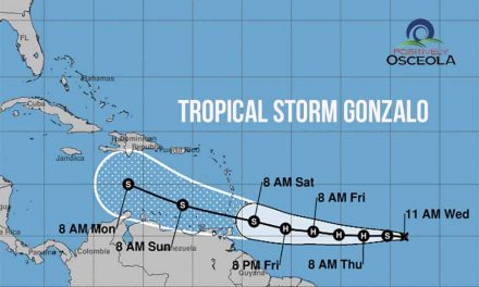
The National Hurricane Center (NHC) has increased the likelihood of a tropical system developing in the Atlantic, which now includes Florida in its long-term forecast. As of the NHC’s 8 p.m. outlook on Saturday, the disturbed weather area is located over the central tropical Atlantic and is expected to interact with an approaching tropical wave in the coming days.
“Environmental conditions are forecast to become conducive for some development in a day or two, and a tropical depression could form around midweek while the system is near or over the northern Leeward Islands, Greater Antilles, or southwestern Atlantic Ocean,” forecasters reported.
The NHC has assigned a 40% chance of development over the next seven days, slightly up from Friday’s forecast when tracking began. The potential path of this system includes a broad range of areas in the Caribbean and the Bahamas, with the Florida peninsula also within the forecast’s scope.
The Atlantic has been quiet since Hurricane Beryl, with its last advisory issued on July 10. This quiet period has been attributed to a significant amount of Saharan dust moving westward from the African coast, which has inhibited tropical development.
Should this system develop into a named storm, it would be called Tropical Storm Debby.
The National Oceanic and Atmospheric Administration (NOAA) has predicted an above-average Atlantic hurricane season, expecting 17 to 25 named storms, of which 8 to 13 could become hurricanes, and 4 to 7 of those may develop into major hurricanes. The Atlantic hurricane season runs from June 1 to November 30.


